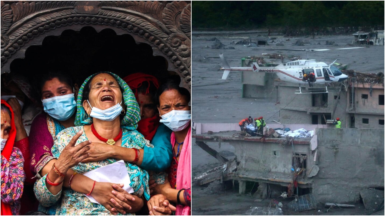
New Delhi: The devastating floods along the Nepal-China border on August 26 have raised fresh questions about disaster preparedness and the sustainability of development across the Himalayan region, offering important lessons for India’s mountain states.
The disaster, which reportedly killed more than 900 people and left thousands missing, has highlighted a changing pattern of Himalayan risks. Experts and officials increasingly recognise that extreme weather events in the mountains can trigger a chain of hazards, making conventional flood-warning systems alone insufficient.

The key lesson is that Himalayan disasters often begin far from the communities that ultimately bear their impact.
The danger can begin high in the mountains
Floods are commonly associated with intense rainfall and rapidly rising rivers. However, high-altitude events can follow a far more complicated sequence.
Preliminary assessments cited in the source material indicate that ice and rock debris may have moved rapidly down a steep mountain slope, gathering water and additional material along the way. A possible ice-rock avalanche in a high-altitude area has also been identified as a potential trigger.
Such events can create a cascading disaster. A glacier or unstable slope may collapse, temporarily block a river, form a natural dam and create a reservoir of water and debris. When that obstruction fails, a powerful surge of water, mud, rocks and trees can rush downstream.
For communities living in valleys, the resulting flood can arrive with very little warning.
Early warning systems need to look beyond rivers
Nepal already has a network of river monitoring stations, automated weather stations, weather radars and systems tracking snow, glaciers and glacial lakes. Regional organisations such as the International Centre for Integrated Mountain Development (ICIMOD) also operate systems designed to identify potential flash-flood risks.
Yet the latest disaster demonstrates the limitations of monitoring systems focused primarily on river conditions.
According to information cited in the source material, water levels in one section of the Trishuli River reportedly rose by around nine metres within approximately 30 minutes, while some monitoring infrastructure was damaged.
The question for Himalayan countries is therefore no longer simply whether an early-warning system exists. It is whether the system can detect a hazard before it reaches the river.
Monitoring needs to extend to unstable slopes, rapidly changing glaciers, expanding glacial lakes and potential natural dams. Authorities also need to identify valleys vulnerable to sudden debris flows and cascading floods.
Development planning must account for risk
Technology alone cannot eliminate the danger. Even the most effective warning system is of limited value if communities have nowhere safe to evacuate.
Mountain settlements need clearly identified safe zones, evacuation routes and locally understood emergency procedures. Traditional Himalayan communities often built homes away from vulnerable riverbanks and on relatively safer terrain, drawing on generations of knowledge about local geography.
Rapid development has altered that pattern in many areas. Hotels, houses and homestays have expanded along rivers, while roads, tunnels and hydropower projects have transformed mountain landscapes.
Infrastructure is essential for economic development, but construction cannot be treated as synonymous with progress regardless of location.
Authorities need clearer assessments of which areas are suitable for settlement and which should remain development-free because of flood, landslide or avalanche risks.
One project cannot be assessed in isolation
Another lesson from the Himalayan disaster risk landscape is the need to assess the cumulative impact of development.
A road, dam, tunnel or hotel may appear manageable when examined individually. But hundreds of interventions within the same valley can collectively alter drainage patterns, river channels and slope stability.
Large infrastructure projects should therefore be evaluated not only on their individual environmental impact but also on how they interact with other projects across an entire watershed.
Planning should account for extreme scenarios, including unusually intense rainfall, glacier collapse, landslides and debris flows.
Historical climate records alone may also no longer provide an adequate picture of future risks. Rising temperatures, changing glacier conditions and increasingly erratic weather patterns mean that planners must account for hazards that may exceed historical experience.
Tunnel and hydropower safety need greater scrutiny
The Nepal disaster should also prompt a closer examination of infrastructure in India’s Himalayan states, where tunnel construction and hydropower development have expanded rapidly.

The issue is not whether tunnels or hydropower projects should be built. Rather, projects must be based on detailed geological assessments and continuous monitoring.
Rock stability, groundwater pressure, seepage and changes caused by excavation need to be monitored throughout construction and operation.
In a young and geologically active mountain system such as the Himalayas, tunnelling is fundamentally different from conventional construction. Geological surveys, advanced rock-support systems and real-time monitoring should therefore form an integral part of project design and safety management.
Tourism also needs a carrying-capacity approach
Tourism is an important source of employment and income for Himalayan communities, but uncontrolled growth can place enormous pressure on fragile mountain towns.
Roads, water supplies, sewage networks, waste-management systems and emergency services all have finite capacities. Tourist numbers should therefore be matched with the ability of individual destinations to safely accommodate visitors.
In particularly sensitive areas, authorities could consider regulated access, digital permits and seasonal limits based on weather and environmental conditions.
Sustainable tourism must ultimately mean safe tourism as well.
A cross-border warning for India
The Himalayan ecosystem does not recognise political boundaries. A hazard originating in the Tibetan plateau can affect Nepal and subsequently have consequences for downstream areas of India and Bangladesh.
India therefore needs a more integrated monitoring system covering glaciers, glacial lakes, landslides, rivers and extreme weather across its Himalayan states.
Satellite imagery, automated cameras, seismic sensors, weather radars and river gauges can generate valuable information. The greater challenge is ensuring that these data are integrated and shared quickly with agencies responsible for emergency response.
India, Nepal, Bhutan and China have different political and strategic interests, but disaster preparedness presents a strong case for technical cooperation.
A regional Himalayan risk map, real-time information-sharing mechanism and cross-border disaster-warning framework could significantly improve preparedness.
Natural hazards cannot be blamed for every loss
After a major disaster, two explanations often dominate the discussion: that the event was entirely natural and therefore unavoidable, or that climate change was solely responsible.
Both may contain elements of truth, but neither should end the discussion about human responsibility.
Glacier collapse cannot always be prevented, and landslides cannot be eliminated. But building on unstable slopes, occupying flood-prone land or allowing excessive construction in vulnerable valleys involves human decisions.
Governments can also determine how many projects are permitted in a watershed, where roads are built and whether evacuation systems are adequate.
The distinction between a natural hazard and human-created vulnerability is therefore critical. While the triggering event may be impossible to stop, the scale of its human impact can often be reduced.
The lesson India cannot afford to ignore
The floods in Nepal should be viewed not merely as a tragedy but as a warning for the entire Himalayan region.
India needs development in its mountain states, but development must be based on a realistic understanding of geological and climate risks. Roads are necessary, but not across every vulnerable slope. Hydropower can contribute to energy security, but individual valleys cannot be treated as limitless project zones. Tourism can support local economies, but destinations cannot be allowed to grow beyond their ecological and emergency-management capacity.
The Himalayas must be treated as an interconnected natural system rather than a collection of isolated construction sites.
The next disaster may not be preventable. But its consequences can be reduced through better science, responsible planning, stronger infrastructure standards, coordinated warning systems and closer regional cooperation.
The Himalayas are already sending signals through changing glaciers, overflowing rivers, landslides and unstable slopes. The choice facing policymakers is whether to respond after every disaster with relief and compensation—or to change development policies before the next catastrophe strikes.