Dehradun: On August 5, 2025, at approximately 1:45 PM, the serene Himalayan village of Dharali in Uttarkashi district, Uttarakhand, was shattered by a catastrophic event. A massive cloudburst—or possibly a glacial lake outburst flood (GLOF), as some experts suggest—unleashed a torrent of water, mud, and debris that swept through the Kheer Ganga river catchment, engulfing homes, hotels, and livelihoods in minutes. This disaster, which struck a key stopover on the sacred Gangotri Dham pilgrimage route, has once again highlighted Uttarakhand’s vulnerability to extreme weather and raised questions about whether lessons from past tragedies have been truly learned.
The Catastrophe Unfolds
Dharali, nestled at 8,600 feet above sea level, was bustling with tourists and locals when the disaster struck. Eyewitnesses described a “wall of water” cascading down the hills, carrying boulders, debris, and silt that obliterated everything in its path. Videos captured by residents and tourists show muddy torrents tearing through the village, swallowing multi-story buildings, shops, and vehicles. “Everything from hotels to markets has been destroyed… I haven’t witnessed a disaster like this before,” an eyewitness told India Today TV. The nearby market area, a hub for pilgrims and trekkers, was reduced to a sludge-filled riverbed. Initial reports indicate that 20–25 hotels and homestays were washed away, with entire sections of the village buried under debris.
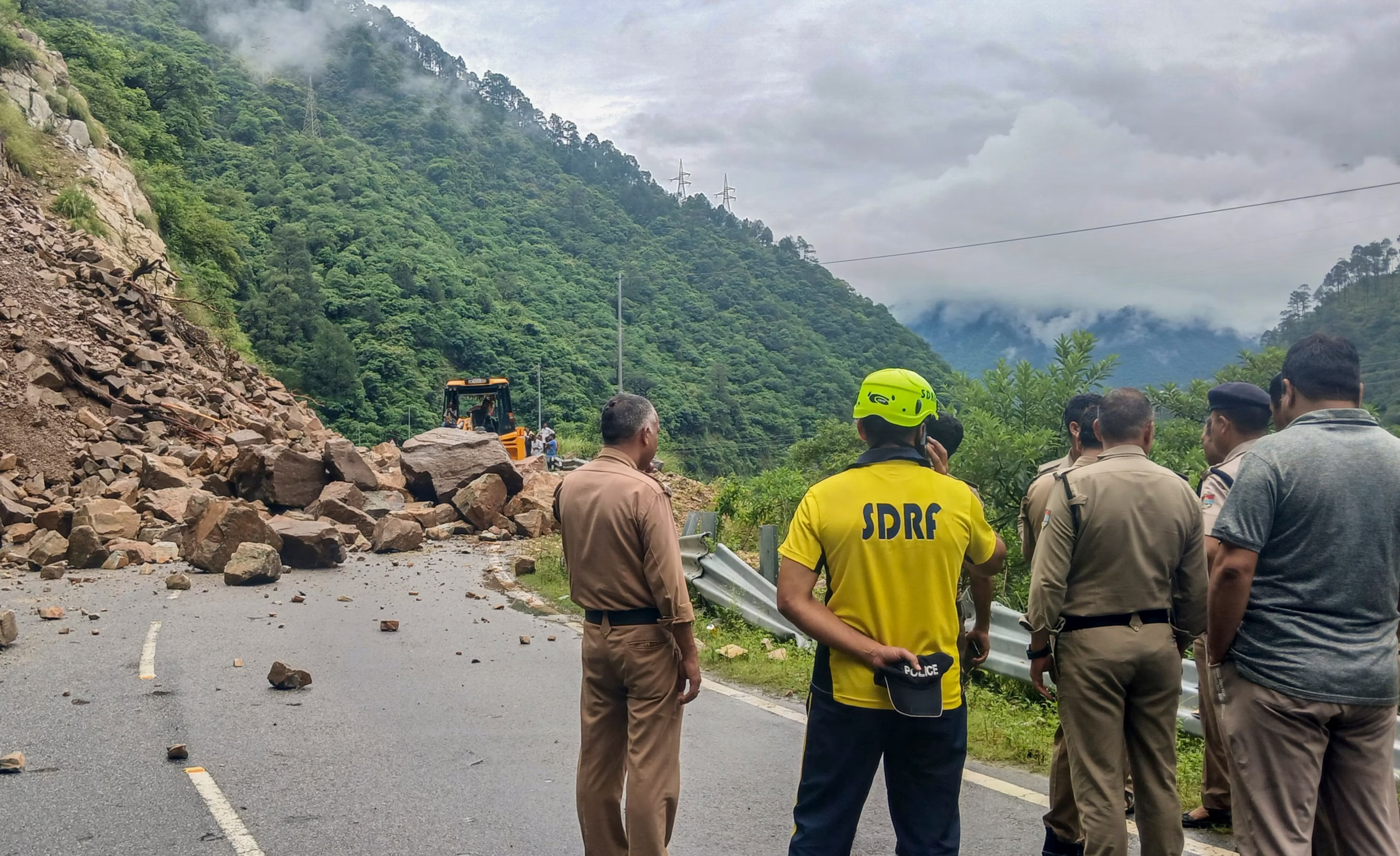
The death toll, as of August 7, 2025, stands at six, with over 50 people still missing. Among the missing are 11 Army personnel, 16 tourists from Maharashtra’s Jalgaon district, and a 28-member group from Kerala. The flash floods also swept away livestock, with 18 goats reported lost in the nearby Banala Patti area. The Gangotri National Highway, a vital lifeline, was blocked at multiple points, including a 30-meter collapse near Bhatwari, severely hampering rescue efforts.
A Question of Cause: Cloudburst or GLOF?
While initially reported as a cloudburst, experts have raised doubts. The India Meteorological Department (IMD) recorded only 6.5 mm of rainfall in Harsil and 11 mm in Bhatwari over 24 hours—far below the 100 mm per hour threshold for a cloudburst. Dr. DD Chauniyal, a geographer at Doon University, suggests a glacial pond burst in the snow-covered mountains north of Dharali may have triggered the deluge. The Kheer Ganga river, originating in this region, likely carried excess water from melting glaciers or a breached glacial pond, exacerbated by recent rains. Posts on X also point to a possible GLOF, noting the presence of glacial lakes above the site. This uncertainty underscores the region’s complex interplay of climate change, glacial instability, and extreme weather.
Human and Environmental Triggers
The disaster’s impact was amplified by human activities. Decades of unregulated construction along the Kheer Ganga’s banks, including hotels and homestays built on flood-prone riverbeds, turned a natural event into a catastrophe. Dr. Chauniyal noted that settlements had encroached on the river’s historic course, which shifted over time, making them vulnerable when the river reverted to its old path. The Char Dham road-widening project, criticized by experts and Congress MP Ranjeet Ranjan as destabilizing eco-sensitive zones, has further weakened the terrain. Climate change, driving glacial melt and erratic monsoon patterns, has increased the frequency of such events, with warmer temperatures funneling more moisture into the Himalayas.
Rescue and Relief: A Race Against Time
The response was swift but challenged by relentless rain and blocked roads. Within 10 minutes of the disaster, the Indian Army deployed 150 personnel, including 150 jawans from the Rajputana Rifles and 12 from the Ghatak Battalion, alongside 100 ITBP personnel and teams from the NDRF, SDRF, and local police. By August 7, 413 people had been rescued, with 190 shifted to safer locations and temporary shelters set up in schools and hotels. The Indian Air Force mobilized Mi-17 helicopters and C-295 aircraft, while the Army established satellite and radio relay communications to reconnect stranded civilians with their families. The NDRF deployed cadaver dogs for the first time in Uttarkashi to locate bodies buried under debris, aiming to provide closure to grieving families.

Chief Minister Pushkar Singh Dhami cut short a trip to Andhra Pradesh to visit ground zero, conducting an aerial survey and meeting affected families. Prime Minister Narendra Modi, Union Home Minister Amit Shah, and Defence Minister Rajnath Singh assured full support, with helplines activated and additional resources on standby. However, continuous rainfall, landslides, and a collapsed highway delayed operations, leaving rescuers to navigate rugged terrain on foot.
Echoes of Past Tragedies
The Dharali disaster evokes memories of the 2013 Kedarnath floods, which killed over 5,700 people, and the 2021 Chamoli avalanche, which claimed nearly 200 lives. Former Chief Minister Harish Rawat called the event “alarming,” noting the increasing frequency of cloudbursts. Congress MP Priyanka Gandhi Vadra and Samajwadi Party leader Akhilesh Yadav urged long-term preventive planning and a renewed focus on Himalayan conservation, criticizing unchecked development. The 2025 cloudburst, following another in Uttarkashi on June 29, 2025, which killed workers on the Yamunotri Highway, underscores a pattern of recurring disasters.
Why Lessons Remain Unlearned
Despite past tragedies, Uttarakhand’s disaster management has been criticized for being reactive rather than proactive. The lack of an integrated early warning system, highlighted by experts after the 2021 Chamoli disaster, persists, with Doppler radar forecasts unable to pinpoint small-scale cloudbursts. Unregulated tourism, with millions flocking to pilgrimage sites like Gangotri, strains the region’s carrying capacity. Construction in eco-sensitive zones, often without geological assessments, continues despite warnings from Supreme Court-appointed committees. The paradox of glacier melt—temporary water surges followed by long-term scarcity—looms large, yet policy changes lag.
A Path Forward
The Dharali cloudburst is a stark reminder of Uttarakhand’s fragility. To break the cycle, experts call for:
Early Warning Systems: Deploy Doppler radars and real-time glacial monitoring to predict cloudbursts and GLOFs.
Eco-Sensitive Zoning: Enforce strict bans on construction in high-risk areas and regulate tourism to sustainable levels.
Community Resilience: Train locals in disaster response and integrate traditional knowledge into planning.
Climate Adaptation: Prioritize reforestation, river conservation, and climate-resilient infrastructure.
The 2025 Uttarkashi cloudburst is not just a natural disaster but a symptom of systemic failures in balancing development with ecological limits. As rescue teams toil amidst debris and rain, the cries of survivors and the silence of the missing echo a familiar refrain: Uttarakhand’s disasters are as much man-made as they are natural. The region’s future hinges on learning these hard lessons—before the next torrent strikes.